The Inlet that Eluded Bass IntroductionThe NSW South Coast's varied and colourful history is well recorded. Stories of its gold rush days and its famous corn trail provide fascinating reading. Local explorer and tour operator, Dennis Moore uses his journalist's and wanderer's background to discuss a curious anomaly of a famous early explorer.The Inlet That Eluded BassThe log of George Bass's expedition in the whaleboat records that this eminent coastal navigator entered and explored Batemans Bay - during the afternoon of the day before he reached it.The anomaly goes far towards explaining the comments in Bass's log.
These observations were entered against the date Thursday 14 December 1797. But on Friday 15 December Bass recorded that he sailed with a sea breeze at ENE.
Reference to today's charts shows that the line of latitude 35° 43' south passes through the North Head of Batemans Bay.  So Bass had at that point reached the bay he supposed he had decribed the day before. The two or three small islands almost certainly were the outcrops later to become known as Three Islet Reef.
The mystery is that, given reasonable visibility, these outcrops would have been deeply etched across an expanse of water, against distant mountain ranges. The Toll Gate Islands, in the centre of the bay's entrance, would have loomed to the southwest, massive and stark. Bass stated his noon latitude, which he could only have established by taking a sun sight with his sextant. How then, with satisfactory visibility for shooting the sun, did he fail to observe that to the southwest was the open bay outlined on Cook's charts? It was an inlet with twice the width and five times the depth westward of the mediocre bight he had explored the previous day. And it was an inlet which, despite being misplaced by Bass, was to achieve importance along with its associated navigable estuary, firstly as a prime port for coastal shipping, then as a popular recreational waterway, with fishing boats, water skiers and passenger ferries. Named Batemans Bay on 22 April 1770 by James Cook, the bay lies south of Port Jackson, somewhat less than half way to the strait which Bass was to establish separated Tasmania from the mainland. Cook recorded that:
He named the bay in honour of Nathaniel Bateman, captain of Lord Coleville's ship the Northumberland, at the time when Cook was serving on her.  It is now completely clear, and was established in 1916 after investigation by R.H. Cambage, that the bay entered and explored by Bass was the open indentation between Point Upright and Wasp Head, into which Durras sea lake drains. Point Upright is noted in Cook's log, and was named by him for its perpendicular cliffs. Durras Inlet's only island is Wasp Island, which lies to the north-east of Wasp Head. It is now completely clear, and was established in 1916 after investigation by R.H. Cambage, that the bay entered and explored by Bass was the open indentation between Point Upright and Wasp Head, into which Durras sea lake drains. Point Upright is noted in Cook's log, and was named by him for its perpendicular cliffs. Durras Inlet's only island is Wasp Island, which lies to the north-east of Wasp Head.A further very evident and remarkable feature not noted by either Cook or Bass is the striking dissimilarity between the rock formations which contain the two bays. The headlands of Durras Inlet are level bedded, generally light coloured sandstone, with here and there a stratum of darker conglomerate. Silhouettes viewed from a distance are of horizontal and stepped points and ledges, terminating abruptly in perpendicular rock faces. To the south, in vivid contrast, the cliffs display complicated fault lines and folded strata, with jagged and rugged outlines. Reefs of jet black chert jut grotesquely and without pattern from the water. Joint lines and bedding planes run in every direction and at every angle and there are many sea caves. In fact it is the geological unconformity between the Cambrian Wagonga Beds and the Permian Sydney Basin sandstones which intersects the coastline between Batemans Bay and Durras. Where the sands of Myrtle Beach are blown by southerly winds against Flat Rock headland, the actual unconformity is exposed in the same rock face. Flat Rock and its headland are the first Permian features, and Richmond Headland to the south is very evidently the northern extremity of the Wagonga Beds. According to geologists, their ages are separated by more than 200 million years. 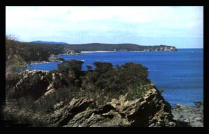
The line of the unconformity runs away to the north, and gradually westward, to take in the distinctively shaped peak Pigeon House, named by Cook. The river Clyde finds its origins in cascades spilling from the sandstone plateaux which typify the mountains north of Pigeon House. It has carved through the horizontal, Permian sandstones into the folded Ordovician bedrock beneath. The crystal clear water tumbles generally southward beneath a closed canopy of deep forest, among rounded, Ordovician foothills, to the tidal limit. Then it lazes peacefully towards Batemans Bay and the hard, coastal, Cambrian rock zone. Eventually, more than twenty years after the George Bass error, the Clyde was named and navigated by Lieutenant Robert Johnston and Alexander Berry, on board the cutter Snapper. Austalian born Johnston was educated in Britain, and it seems he saw a parrallel to the Scottish river Clyde. Berry, who gave his own name to another coastal township, was already involved in the cutting and shipping of cedar from the Illawarra district in the north. No doubt his part in the expedtion was prompted by a desire to locate navigable access to further stocks of cedar. Both men and their crew must have been singularly impressed as reach after broad, meandering river reach was cleaved by the bow of their vessel, as it turned through every bearing on the compass. The Clyde resembles Sydney Harbour or the Hawkesbury River, in that it is an inundated valley, carved during lower ocean levels in a previous ice age. However the Clyde lacks the high, protruding sandstone ledges of the Hawkesbury and the foreshore shelves of Sydney Harbour. Its embankments are generally timbered and sloping. W.A. Bayley, in Behind Broulee records that the Snapper sailed 25 miles (40km) upstream from Snapper Island, at the river's mouth, on 30 November 1821, and a further 10 miles (16km) the next day. Sailing the further 16 km is an almost impossible feat as there are a series of rocky rapids covered only by the highest tides. However, maritime historian Graeme Andrews has records of the paddlesteamer William the Fourth being taken to the township of Brooman, which approximates the 56 km total. During more recent years, coastal steamships terminated at the so called Shallow Crossing wharf, approximately 40km from the river mouth. Here they loaded timber brought by road from the sawmill at Brooman. Bass's myopia of December 1797 probably did little to alter the course of history, because the Clyde did not assume any great significance as a navigable waterway until the 1850s, thirty years after its exploration. The government surveyors Florence and Hoddle noted signs of earlier settlement near the Clyde in 1827 and 1828, and a land grant of 640 acres (259ha) was made on Nelligen Creek in 1829, but agricultural development of the small fertile flats was slow. 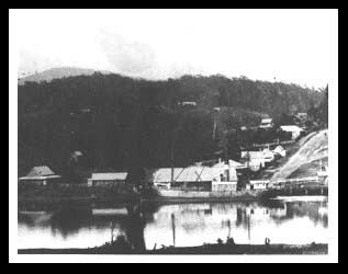
Following discovery of gold in the Araluen Valley in 1851, the Clyde and its downstream tributary, the Buckenboura gave ocean-going vessels their closest possible landing to the diggings. These Araluen diggings were no more than a half day's ride from the Buckenboura valley, by packhorse trail across the intervening ridge. An island in the lower Clyde received the name of Budd, after an early Araluen store keeper, and Chinese trading between the diggings and Sydney are thought to have connections with the naming of Chinamen's Point, downstream from the Buckenboura mouth. But it was a petition by landowners and citizens of Braidwood in March 1852 which resulted in the Clyde as a major trade route being drawn in on the map. Braidwood as already well established as a prosperous pastoral and agricultural centre, and the petition was to the Surveyor General, Sir Thomas Mitchell, seeking a route to be surveyed from Braidwood to the Clyde. Construction of a road to replace the packhorse trails was commenced in 1853, and was in use during 1856. The road, which crossed the Sugarloaf, now Clyde Mountain, greatly enhanced the movement of goods to and from Sydney, not only from Braidwood, but from the Monaro Plains. The settlement at Nelligen became the main port township and a report published in the Sydney Morning Herald of 5 October 1860 states that there were four public houses, two stores, two blacksmiths, and one baker, all of whom were doing a roaring trade. There were upwards of 500 horses and nearly as many bullocks kept continually on the road between Nelligen and Braidwood and neighbouring goldfields. 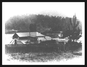
An extension of the railway line from Goulburn to Cooma, opened in 1889, brought the railways into direct competition with the wagon trail and steamship link. Gold fever diminished as claims petered out and by the turn of the century the pace of life in Nelligen had considerably diminished. During the early 1900s the Illawarra and South Coast Steam Navigation Company recognised that their continued operation would centre on the South Coast's timber industry. The first steamship recorded as navigating the Clyde River to Nelligen did so in 1853. It seems most likely that she was the PS Nora Creina under charter carrying men and equipment to build the road towards Sugarloaf. During the river's heyday, two steamers would call at Nelligen each week. The last coastal freighter, the SS Bergalia, depated Batemans Bay, loaded with hardwood railway sleepers in April 1957. Even Durras Inlet, despite the poor opinions expressed by Bass, was to see service as a minor port.  Wasp Head, still called Mill Point by local residents, affords an excellent lea from south and south-east winds. A saw mill, where rusted steam boiler still remains, operated right at the water's edge, and steamships were able to pull in close to the sandstone shelf to load slings of sawn hardwood. A set of wooden tram tracks ran inland, and timber from other sources could be hauled by horse teams to Mill Point for loading. Wasp Head, still called Mill Point by local residents, affords an excellent lea from south and south-east winds. A saw mill, where rusted steam boiler still remains, operated right at the water's edge, and steamships were able to pull in close to the sandstone shelf to load slings of sawn hardwood. A set of wooden tram tracks ran inland, and timber from other sources could be hauled by horse teams to Mill Point for loading.Cook discovered Batemans Bay, Bass mislaid it, then Johnston and Berry paved the way for trade into the Clyde River. Now coastal steamships are a memory, and the new era is of recreational boating. But the tranquil waterway and the ruggedly beautiful coastline and mountains remain largely unspoiled. Read further interesting historical accounts of our past. Nelligen gold rush days The Corn Trail on the Clyde The Dray Trail to Prosperity
|