|
DESCRIPTION OF THE "GREATER" MURRAMARANG NATIONAL PARK REGIONAL SETTING The area under consideration extends east of the Princes Highway from Bawley Point (south of Milton-Ulladulla), to north of Batemans Bay - the two major tourist centres on the South Coast (Maps 1 and 2). It is within two hours drive of the cities of Wollongong and Canberra, both with populations in excess of 250,000 and three hours drive from the southern suburbs of Sydney with its population of over three million. Ready access from Sydney and Wollongong is afforded via the Princes Highway. Spur roads link the Highway to Southern Highland towns. The Kings Highway links Canberra and Queanbeyan with Batemans Bay and is joined near Braidwood by a subsidiary road from Goulburn. Both the Princes and Kings Highway have been continuously upgraded over the last decade. CLIMATE The climate of the area can be classified as mesothermal with long, mild summers. It is controlled by the Pacific Subtropical and Subpolar Maritime Air Masses, as well as the stable and dry to very dry Subtropical Continental Air Mass. The annual rainfall for the area is approximately 1,000 mm. The western slopes of Durras Mountain receive significantly higher rainfall due to its particular topography. Rainfall is fairly uniform throughout the year, with mean summer rainfall slightly higher than mean winter rainfall. Very heavy storm events associated with an active depression centered off the coast, may occur. Falls in excess of 400 mm in a 24 hour period have been recorded. Temperatures tend to be moderate varying between a mean maximum in the hottest month (February) of about 24oC, and a mean minimum in the coldest month (July) of about 6o C. Occurrence of frosts is almost nil. Very hot days, with temperatures over 38oC, are experienced on average once per year. The average number of hours of bright sunshine per day is 7.4 hours. Light to moderate north-east to south-east winds prevail in the summer months and westerly winds in the winter months (Forestry Commission of NSW, 1983). Vegetation influences climate at the macro and micro levels. Growing evidence suggests that undisturbed forest helps to maintain the rainfall in its immediate vicinity by recycling water vapour at a steady rate back into the atmosphere and through the canopy’s effect in promoting atmospheric turbulence. On smaller scales, vegetation has a moderating influence on local climates and may create quite specific micro-climates. Some organisms are dependant on such micro-climates for their existence (Department of the Environment , Sport and Territories, 1993). Forest harvesting and the clearing of native vegetation are major contributors to greenhouse gas emissions. The net total of greenhouse gases emitted in Australia 1990 was the equivalent of Native vegetation clearance can also affect regional weather patterns. Recent research indicates that regional rainfall and atmospheric energy patterns have been changing in certain areas which have been extensively cleared (Department of the Environment , Sport and Territories, 1995b). GEOLOGY Most of the area forms part of the Lachlan Fold Belt which is a complex area of Paleozoic rocks extending northwards from Victoria through south-eastern NSW (Map 4). These strata have been folded several times in the Paleozoic period. Relatively uniform Permian sediments (280-230 mya) of the Sydney Basin overlie the Paleozoic rocks in approximately one third of the area, reaching as far south as Dark Beach, just south of South Durras village. These have produced sandy beaches, wave-cut platforms, regular cliffs and headlands and offshore islands. The area contains sites of geological significance. The Snapper Point Nursery Bed between Pretty and Merry Beaches is an outstanding record of trace-fossils, including the oldest record in the world of decapod fossils. They are an important record of palaeoclimate, palaeogeography and sedimentation processes in the early stages of the formation of the Sydney Basin. The sediments here and at Pebbly Beach and Wasp Head contain a diverse and rich fossil assemblage of bivalves and brachiopods. Plant and marine fossils from these locations have provided important information on the Permian flora and fauna within the Sydney Basin. This has assisted in the understanding of the evolution of the Australian flora and changes in environmental conditions since the Permian era (Australian Heritage Commission, 1983). Other significant geological features include:
These geological features are of considerable scientific importance and present outstanding opportunities for teaching and research in paleontology and stratigraphy (NSW National Parks and Wildlife Service, 1998). The Snapper Point Nursery Bed and those at Pebbly Beach and Wasp Head are on the Register of the National Estate. Although now protected within Murramarang National Park, the integrity of the sites has been reduced in some areas by illegal fossil collection. South of Durras Lake the major geological group is the Early Ordovician Wagonga Formation (500-450 mya) These crumbled, metamorphosed sediments include conglomerate, agglomerate, slate, sandstone and phyllite. During the Permian period the Wagonga Beds sank beneath the sea and were covered by accumulated eroded sediments which formed the Permian Conjola Formation. The unconformity, the junction of the Ordovician Wagonga Formation and the Permian Conjola Formation is exposed and clearly seen at Dark and Myrtle Beaches, south of Wasp Head. The highest point in the area is Durras Mountain (283 metres), a basalt remnant of a Tertiary lava flow which buried the entire district in the last 60 million years. The rich brown basalt soil supports a diverse rainforest on the flanks of the mountain (Wright, 1996). Mesozoic essexite (a variety of dolerite) intrusions invade the Permian formation from approximately Nuggan Point to Wasp Head. These add to the geological complexity of the coastal formations and their suitability for education and research. The area’s Quaternary deposits (1 mya to present) are located along the coast and around the lagoons. These contain deposits of quartz and shelled beach sand, estuarine sediments and rich organic deposits in swamps. GEOMORPHOLOGY The area contains two distinct landforms - coastal lowlands and hills. The coastal lowlands consist of rolling and undulating country with restricted plains. The dominant scenic feature is the cliffed coast with minor sandy bays. Behind the coast is gently to steeply rolling country under forest, dominated by the Murramarang Range. The lowlands contain the estuarine lake systems of Durras, Willinga, Meroo and Termeil. Durras, Meroo and Termeil have catchments and shorelines in natural condition and are the only lakes of this kind with intact ecosystems between Ulladulla and Nadgee National Park on the border with Victoria (Australian Heritage Commission, 1983). Durras Lake, within the "Greater" Murramarang National Park, is the drowned river valley of Ryan’s Creek. During the Quartenary Period the sea level rose to its present height flooding the lowlands and lower valleys to form embayments while the waves cut cliffs and rock platforms in the new coastline. Initially many of the embayments were open to the sea. However, sand barriers were soon built within them or across their mouths by wave action which brought sand from the continental shelf. The closure of inlets and embayments by the growth of sand barriers created numerous lagoons which evolved according to the permanency of the barrier, the sediment supply and runoff. Where the closure was impermanent the resulting lagoons are still influenced by the rise and fall of tides. The sand barriers are built up during calm weather with moderate surf and breached by storm waves or during periods of heavy rain when the water level in the lagoon rises and breaks through the sand barrier. Water in these lagoons is brackish or salty (Australian Heritage Commission, 1983). SOILS Soil distribution in the area is controlled mainly by the nature of the underlying rock and the spread of weathering and erosion products across the slope profile (Map 5). The major soil groups of the area are massive earths, brown and grey-brown earths, alluvial soils and uniform sandy soils. The greater part of the area consists of brown and grey-brown soils and massive earths. Those that are derived from the Ordovician and Permian sediments generally have good drainage characteristics. The brown soils derived from the Tertiary Basalt on Durras Mountain are very fertile and support a richer and more varied vegetation on the drainage and erosion paths from this cap. The main characteristics of each soil group are:
Soils across the area are classified as moderately rich to rich with moderate to good drainage characteristics. The loss of vegetation can contribute to the salinisation of soils, leaching of nutrients, laterisation of minerals and accelerated erosion of topsoil, reducing the land’s productivity. Trees, on the other hand, lower the water table and remove deposited salt from the upper soil horizons. Soil protection by maintenance of biological diversity can preserve the productive capacity of the soil, prevent land slippage, safeguard coastlines and riverbanks and prevent the degradation of riverine, estuarine and coastal fisheries by siltation. Trees and similar vegetation also assist in soil formation. A significant contribution is the introduction of organic matter through litter formation and the decay and regeneration of tiny fibrous roots, both of which facilitate microbial activity. Another contribution is through the affects of root systems which break up soil and rock leading to, amongst other things, penetration of water. Root systems also bring mineral nutrients to the surface through root uptake. Organic matter formed by the decay of tiny fibrous roots can also bind with minerals, such as iron and aluminium, which can reduce the potential deleterious effects of these minerals on other vegetation. The removal of a substantial portion of the overstory and understory vegetation by logging and burning can dramatically alter the soil balance and result in serious long term and far reaching declines in productivity (Department of the Environment, Sport and Territories, 1993). 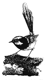 Superb Blue Wren (Malurus cyaneus) Lesley Wallington – FoD
BIODIVERSITY Australia is one of only 12 countries with such a rich variety of life that it has been classified as "megadiverse." Many of our species (some 45% of our native bird species and 84% of our mammals for example) are endemic to Australia,. Many species have yet to be classified.Yet historically, Australia has not done well in caring for this rich diversity of life. Although species extinctions are part of natural history, the rate of extinction in Australia in the two hundred years since European settlement has accelerated dramatically. During this time, Australia has established the highest known rate of mammal extinctions in the world. Of our 258 known species of mammals, 138 are either extinct, endangered or vulnerable. Seventy six species of Australian vascular plants are presumed to have become extinct since European settlement and 5 031 are considered to be rare or threatened. These are conservative estimates. Half of all animal extinctions in Australia have occurred this century, with six species having become extinct in the last 50 years (Young et al., 1996). Our interactions with natural systems now, will determine how many more plants, animals and birds will be lost. The loss of biological diversity is perhaps our most serious environmental problem. Whether we look at wetlands or saltmarshes, mangroves or bushland, inland creeks or estuaries, the same story emerges. In many cases, the destruction of habitat, the major cause of biodiversity loss, is continuing at an alarming rate (Department of the Environment , Sport and Territories, 1996). The Commonwealth Government’s National Strategy for the Conservation of Australia’s Biological Diversity was formulated to protect biological diversity and maintain ecological processes and systems. The Strategy was prepared in consultation with business, conservation movement and industry representatives, including the Australian Forestry Council. The Honorable Bob Carr MP signed the Strategy on behalf of the people of New South Wales committing his government to implement the Strategy as a matter of urgency. Politicians, scientists and the public now accept that our survival depends on elements of biological diversity. Biodiversity provides the critical life-support systems that make human life possible. It is also important for aesthetic and cultural reasons. Many people obtain cultural identity, spiritual enrichment and recreational enjoyment from elements of biological diversity and it provides the basis for Australia’s domestic and international tourism industry. Biological diversity provides us with great economic returns, for example in the provision of food and fibre, timber resources, medicines, control of pest organisms and crop pollination. The conservation and maintenance of biological diversity are also important for ethical and inter-generational equity reasons in that no generation has the right to sequester the Earth’s resources solely for its own benefit. This is one of the major platforms for ecologically sustainable development and the Inter-Governmental Agreement on the Environment (IGAE) endorsed in 1992 by the Commonwealth and all State Governments. Dennis Saunders (1998), assistant Chief of CSIRO’s Wildlife and Ecology is deeply concerned at the continuing loss of biodiversity. Losses of habitat in Australia inevitably mean losing a major portion of the species dependant on them. In losing those species he warns, "you lose their interactions with the environment which influence system processes and you compromise the productive potential of the land itself." In a number of areas there is not enough information to assess the situation. Some types of forest are threatened with disappearance and we cannot be certain others are adequately protected to ensure their survival. Our system of reserves is patchy, with areas of poor biodiversity often better protected than areas of high biodiversity, because the poorer areas also have less economic value (Department of the Environment , Sport and Territories, 1996). Conservation areas are often small. In the coastal zone of New South Wales, existing protected areas are not preserving the processes necessary for coastal ecosystems (Hamilton, 1996) How much biological variety can we lose? What will be the effects of a progressive loss of biodiversity? No one exactly knows how many species exist, let alone how they all fit together. There are estimated to be somewhere between 10 and 30 million species on our planet. Most of those are micro-organisms, small fungi, invertebrates and insects and most microbes have not even been given a name (Department of the Environment , Sport and Territories, 1993). Knowledge of invertebrate fauna at the most simple presence/absence level is almost unknown for the forests of the " Greater" Murramarang National Park.The relationships between native vegetation clearance, habitat loss, fragmentation, and biodiversity decline are being increasingly recognised. Two working groups of the Prime Minister’s Science Council 1992, inferred that the factors causing biodiversity loss centre primarily on habitat destruction or modification and that first and foremost, by far the major factor has been the clearing of native vegetation. This finding was supported by the New South Wales State of the Environment Report and the Ecologically Sustainable Development Working Party on Biological Diversity and numerous other scientists and scientific bodies over the past decade. The Biodiversity Unit of the Commonwealth Department of Environment, Sport and Territories (1995) defines native vegetation clearance as "the removal of a significant proportion of one or more of the vegetation strata in an ecosystem." The 1996 State Forest harvesting plan for Benandarah State Forest Compartment 133 proposed to remove up to 50% of the forest canopy from up to 86% of the 302 ha. compartment. In 1987, 52% of the 214 ha., Benandarah State Forest Compartment 128 was harvested and post-logging burning removed ground litter and much of the understory from more than half the Compartment. Operations on this scale undoubtedly have dramatic short term effects on flora and fauna. In many cases these effects will persist into the long term, permanently changing forest composition and structure. Many coastal areas of New South Wales have been heavily modified by vegetation clearance. All major river valleys or plains have been extensively cleared, including the Bega and lower Shoalhaven (Department of Environment, Sport and Territories, 1995). Urban development such as the ‘strip’ from the southern boundary of the "Greater" Murramarang National Park to Moruya has excluded most of the original native species. Coastal forest in New South Wales is a fast diminishing resource.THE BIODIVERSITY OF THE "GREATER" MURRAMARANG NATIONAL PARK It is perhaps easier to assess whether an area is ‘biodiverse’ by comparing the number of species and the complexity of communities with another area acclaimed for its high biodiversity. Jervis Bay is regarded "as very special in a biodiversity sense. It is the fulcrum between northern and southern floras and faunas, both on land and in the sea. The landforms also add to the complexity and variety of biodiversity at species and landscape level (Australia Nature Conservation Agency, 1995). There is no disputing that Jervis Bay is a special place in Australia and the declaration of its Commonwealth and New South Wales national parks were visionary political decisions. The "Greater" Murramarang National Park is also a special place in a biodiversity sense. The variety of landscapes from the convoluted coast to the top of Durras Mountain, rainforest pockets, wet forests and dry sclerophyll ridges, saltmarshes, seagrass beds, wetlands, swamps, creeks and Durras Lake combine, in the same way as at Jervis Bay, to add to the complexity and variety of biodiversity and aesthetics at species, community and landscape level. Forty six fish species, 9 mollusc and 5 crustacean have been taken by commercial fishers from within Jervis Bay (Australia Nature Conservation Agency, 1995). Thirty six species of fish have been caught in Durras Lake, 1 species of mollusc and 8 crustacean (Appendix 8). In Ocean Zone 8, offshore from the "Greater" Murramarang National Park, 140 species of fish, 18 mollusc species and CSIRO Wildlife and Ecology forest ecologists recorded 108 species of forest birds during their 1987-88 field seasons in Jervis Bay. Twelve are threatened and the region has seven avian pest species (Australia Nature Conservation Agency, 1995). The "Greater" Murramarang National Park has to date 136 species of forest bird recorded (and a further 171 species of lake/ocean birds, for a total of 207 species (figures not available for Jervis Bay). Fourteen birds are threatened and there is only one pest species - the starling with the limited range of South Durras village (Appendices 2 and 4). Twenty eight species of mammal were recorded by CSIRO Wildlife and Ecology forest ecologists in Jervis Bay, 12 of those threatened and 9 regarded as pests. The "Greater" Murramarang National Park has a total of 45 species of terrestrial mammal, 11 threatened and 6 pests. A further 5 mammal species have been recorded on the beaches or bays of the park with 2 of these threatened (Appendices 3 and 4). Little work has been done in either area on reptiles, amphibians or invertebrates. Both regions support a wide range of vegetation communities with large undisturbed areas. The "Greater" Murramarang National Park does not have Jervis Bay’s mangrove community or extensive heathland. Over 400 flora species have been recorded in the "Greater" Murramarang National Park (Appendix 1). The comparison allows one to appreciate the high biodiversity in the "Greater" Murramarang National Park. The NSW National Parks and Wildlife Service (1998) accepts that the current narrow, discontinuous Murramarang National Park offers limited security to its biodiversity. "The viability of animal habitats is to a large extent dependent on the continued existence and sympathetic management of the adjacent state forest." Integrated harvesting is not a sympathetic forest management practice and cannot guarantee viable animal habitats nor biodiversity security.
Australia has the second-highest number of plant species threatened by extinction of any country in the world. About 14.4% of Australia’s 15 638 known plant species are listed in the World Conservation Union (IUCN)’s Red List of Threatened Plants (Hogarth, 1998). The "Greater" Murramarang National Park has over 400 recorded plant species (Appendix 1).OVERSTORY The forests of the south coast of New South Wales are synonymous with Spotted Gum (C. maculata), the dominant forest overstory species in the "Greater" Murramarang National Park. Around 35% of the total forest area is Spotted Gum. Stands of Spotted Gum associated with Sydney Blue Gum (E. saligna), Blackbutt (E.pilularis), Bloodwood (C. gummifera), Stringybark (E. globoidea), Bangalay (E. botryoides) or Grey Ironbark (E. paniculata) account for a further 57% (State Forests, 1996). The Spotted Gum forests of the present Murramarang National Park are the largest by area in any New South Wales national park (Wright, 1996).In his studies of forest communities of the Batemans Bay region, Dr R.G. Florence (1996) of the Australian National University’s Department of Forestry, found that landform relief, soil fertility and soil properties all play an important part in delimiting the different species of overstory species. Rainforest was found on soils of highest fertility and better physical soil conditions, followed by high quality vegetation communities dominated by Spotted Gum. The high productivity of the Spotted Gum communities was reflected in their leaves and litter with phosphorus and foliar calcium levels markedly higher than those communities dominated by Sydney Peppermint (E. piperita), Blackbutt or Bloodwood. Sydney Peppermint is uncommon in the park. This confirmed the results of a study of land use allocation and biological conservation in the Batemans Bay Forests by CSIRO scientists Braithwaite, Belbin, Ive and Austin (1993). They examined a wide range of forest values in national parks, state forests and on freehold land and from them classified forest sites as to their ‘site productivity.’ ‘Site productivity’ they suggested was a direct measure of the value of a piece of land for timber production as well as for other forms of primary production. They found that the four vegetation associations characteristic of sites of maximum productivity were, (i) Spotted Gum (ii) Spotted Gum with Sydney Blue Gum (iii) rainforest and (iv) Spotted Gum with Stringybark. These associations dominate the "Greater" Murramarang National Park and represent a wealth of timber resource. The dilemma is that they are also prime biodiversity habitat.Site productivity is a crucial issue in ensuring a genuine Comprehensive, Adequate and Representative reserve system. Too often sites of low biological productivity are reserved at the expense of high productivity sites. Braithwaite, Belbin, Ive and Austin also discovered that the most productive forest sites and their vegetation associations were the least represented in National Parks and the most extensively disturbed by logging or clearing. In fact only 3.5% of the area’s Spotted Gum forest was in national park, 55.7% under State Forest tenure and 40.8% freehold - and only 8% of the Spotted Gum forest type was ‘minimally disturbed.’ In contrast, of the three vegetation associations which dominate poorer sites, more than 38% by area was in national park and of each association, more than 74% remained in a minimally disturbed or undisturbed condition. Braithwaite, Belbin, Ive and Austin concluded that "in the conservation management of these (the Batemans Bay) forests the accumulating evidence is: (i) The significance of the portions of forest of high site productivity should not be underestimated. (ii) Such portions and patches should always be included in reserve areas (iii) The FCNSW (State Forests) has obligations, perhaps not fully hereto appreciated, to manage the areas of high site productivity giving appropriate recognition to their special and specifically identified conservation values. The FCNSW is the custodian of the predominant proportion of the total forest estate remaining of areas of high site productivity; an estate that will in all likelihood continue to diminish in size. (iv) But finally and above all, further loss of forest areas of high site productivity through clearing should be avoided."
"Rainforest is the single most important biological resource we hold for Australia’s future" To many people, rainforests are the pinnacle of Nature’s achievements. They are unequalled among the world’s ecosystems for the range of plants and animals for which they provide a home. Australia is fortunate in having some of the world’s rainforests but not much remains. Only two and a quarter million hectares of rainforest survive in Australia today. They would fit into one third of Tasmania. Reduced to thousands of small remnants and dispersed around a 7 000-kilometre stretch of coastline, they cover just three-thousands of the land surface. That is all that Australia has of a legacy that once covered the continent, that was the ‘green cradle’ of our biological heritage, hanging on against all odds of droughts, fires, invading alien plants and animals and successive droves of people who felled and burned six million hectares of the richest and best of our biological wealth. Forests are rare in Australia, covering less than five per cent of this, the driest continent on Earth. Rainforests are rarer still, covering less than 0.3%. What remains is highly fragmented, set in a sea of hostile environments and erratic climate. Australian rainforests, where so many lineages of ancient Gondwana miraculously survive, today face an extinction crisis, largely in out hands. We will lose that irreplaceable heritage unless we as a nation care enough and act. New South Wales has lost three-quarters of its rainforests, more than any other State. The Big Scrub, 750 square kilometres of subtropical rainforest that once stretched between Byron Bay and Lismore, is virtually gone. The tall rainforests of the Comboyne Plateau and the Illawarra have all but been obliterated. What remains of the State’s rainforests is only partly protected and significant areas are threatened by management practices in surrounding fire-prone forests (Keto and Scott, 1995). It is well documented that rainforest is particularly vulnerable to changes in hydrological regimes and increased risk of fire, associated with logging adjoining forest types. Adequate protection of rainforests requires protection on a sub-catchment basis. Appropriate protection would ensure that remnant and rainforest would have the capacity to expand as climate variations allow. Warm temperate/subtropical rainforest grows on the steep slopes between Pretty and Depot Beach and on the western side of Durras Mountain and on fertile soils in gullies and sheltered gully heads throughout the park. Rainforest also occurs in littoral locations at Richmond, Oaky, Depot and Pebbly beaches and some of the bays to the north. There is also an extensive area of rainforest in Compartments 134 and 135 in Benandarah State Forest leading to the edge of Durras Lake. These rainforests have State-wide significance from a botanical point of view. They are a particularly unusual and well developed mix of warm temperate and subtropical rainforest species. Huge trees of Soapy Box (also known as Churnwood), Jackwood, Black Pencil Cedar (Polyscias murrayi) and Crabapple form the canopy while underneath thrive such elements as Lilly Pilly (Acmena smithii), Sassafras (Doryphora sassafras), Cabbage-tree palm (Livistonia australis), Tree Fern (Cyantea australis), Ceratopetalum apetalum, Guioa semiglauca and Scentless Rosewood (Synoum glandulosum). Other subtropical rainforest species present are Red Ash, Anchor Vine (at its southern limit) and Elk Horn Vine. Coachwood (Ceratopetalum apetalum) is common and quite large for this species (Floyd, 1990). The existence of Bangalow and Cabbage Tree Palms (Livistona australis), three species of tree fern and well-developed, epiphytic Bird’s Nest Ferns (Asplenium australasicum) in close proximity to each other give a picture of a healthy rainforest structure. (Wright, 1996). These rainforest remnants are of high biogeographical significance as small remaining pockets of the once extensive rainforests of the region. (NSW National Parks and Wildlife Service, 1998). The Cabbage-tree palm and the Tree Fern are protected species.The rainforests are also significant for the large number of sub-tropical/warm temperate rainforest plants which occur here at or near the southern limit of their distribution range. These include Ceratopetalum apetalum, Callicoma serratifolia, Clerodendrum tomentosum, Crytocarya microneura, Diospyros australis, Endiandra sieberi, Glochidion ferdinandii, Rhodamnia rubscens, Palmeria scadens and Guioa semiglauca (Australian Heritage Commission, 1983). The rainforest on Durras Mountain contain the most southerly examples of Cooper’s Tree Fern and the Bangalow Palm (Archontophoenix cunninghamiana) (Wright, 1996). Rainforest is especially vulnerable to fire. Where fires do burn into rainforest there is an opportunity for eucalypts to become established, to gain dominance over rainforest species, and to form a mixed sclerophyll-rainforest community. Prescribed burns which burn up to the rainforest margin will cause attrition to the margin and favour the invasion of sclerophyllous species (Florence, 1996). Floyd (1990) notes that "some sections of the original rainforest appear to have been burnt and are now virtually an impenetrable vine thicket. Thus these forests require protection from both wildfire and control burning." The small size of the rainforest pocket found at Oaky Beach is particularly vulnerable to fire and exposure to wind. It has also been subject to severe degradation by inappropriate use on adjoining State Forest land (NSW National Parks and Wildlife Service, 1998). Understory The understory is characterised by Burrawang (Macrozamia communis), Bracken Fern (Pteridium esculentum) and grasses in dry to relatively moist locations. In some moister areas, the Burrawang Palm gives way to the Cabbage-tree palm (Livistonia australis). In drier locations such as ridges and gentle north-facing slopes, the understory is dominated by Acacia, Casuarina and Banksia species. The understory of the gullies is dominated by Black Wattle (Acacia mearnsii), Callicoma serratifolia and Blueberry Ash (Elaeocarpus reticulatus).
Other significant plant communities include:
|